Determining Breaklines
Breaklines represent significant breaks in a terrain model, usually at a ridge, edge of pavement, ditch or other linear feature. The Smart Snap tools can be used to determine the highest or lowest point within a confined range and make that point available to a MicroStation tool for feature placement.
To select the appropriate point, set the diameter of the Smart Snap to include only the points immediately around your target area. If it is an edge of pavement, set the diameter small enough to exclude nearby features such as a ditch or sidewalk. Set the axis to be the Z axis so the pointer extracts points from above. The height setting is less important unless there are neighboring points at a completely different elevation such as vegetation. Reducing the height allows faster processing since the amount of points evaluated is reduced.

Toggle the Smart Snap on and select the MicroStation tool for placement. As you move around, the Smart Snap will select the appropriate point depending on your settings.

In this case, Smart Snap is selecting a point off the cursor position because it has determined that is the lowest point in the search area. A data point will select that point and the line end point will be drawn there.
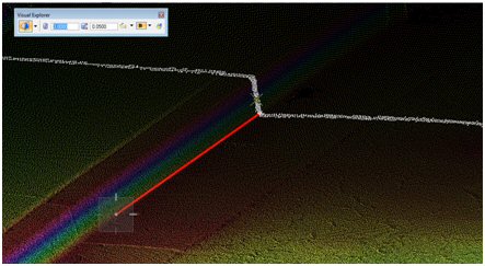
Visual Explorer can be used in conjunction with Smart Snap to perform Quality Assessment in real time and to identify wrong points resulting from noise for example. In the example below, Visual Explorer is used in cross sectioning mode. The points in the cross section are recolored in real time in white.